Why we love it
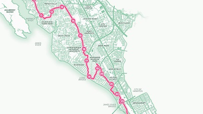
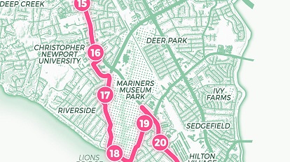
This map combines the passions of running and cartography into one stunningly minimalist marathon route depiction. Cartographers often illustrate enthusiasm for their interests by bringing them to cartographic life in a beautiful map. We love how this cartographer created a gorgeous two-toned marathon map, complete with mile marker points and a route elevation profile.
Why it works
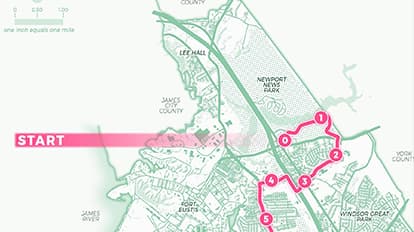
This map brings the One City Marathon route into ultrafocus in two views, offering beauty and minimalism. The first view of the route is done in a bright, crisp hue displayed atop a clever, contrasting hue for remaining map information. The route's elevation profile provides the second view, depicting at which distance runners will encounter hilly stretches and flat terrain. This map works because it simplifies each detail and establishes an efficient display for the marathon route.
Important steps
Find or create the route
Runners and race hosts share downloadable KML-driven race maps, eliminating the need to collect GPS points and convert to KML data. Once KML data is obtained, verify that you have the official race-certified route. Correct any deviations using ArcGIS Pro.
Add mile marker points
Create a separate point data layer for the mile markers. Ensure they correspond with the race-verified mileposts.
Create route elevation profile
With the route as the input line feature, use the Profile tool from the ArcGIS Pro Elevation toolset. Provide a digital elevation model (DEM) source to calculate the elevation or use the default 90-metre resolution Shuttle Radar Topography Mission (SRTM) data.
Requirements
Data & software
Data sources and the race route include OpenStreetMap and City of Newport News open data. The cartographer used both Adobe Creative Cloud and ArcGIS Pro to design this featured One City Marathon map, although he has created entire race route maps using only ArcGIS Pro.
Analysis
Smooth the background data using the Generalisation toolset from the ArcGIS Pro Cartography toolbox. This tool allows data to be refined appropriately for the map's scale.
Time
This map took about 25 hours to make. This time includes data collection and simplification, profile creation and design.
Tips and tricks
Keep it simple
Don't let your race route get lost in dense surrounding data. Keep it simple by highlighting your route with a bolder hue against a subdued background of orienting data like streets, neighbourhoods and a muted hillshade.
Feature local landmarks
Foot races are celebrated by host cities with pride. Incorporate local knowledge like place-names and landmarks special to the region you're mapping. This gives your map a warm characteristic for locals and provides regional knowledge to visitors.
Add orienting features
In addition to orienting readers with a north arrow and scale bar, features like start and finish lines and directional arrows - if the race path overlaps itself - can also be helpful.
Resources
Map Author
Jonah Adkins
I am a cartographer from Newport News, Virginia. I have been working with GIS technology since 1999, learning and applying my skill sets with local governments and federal agencies and, recently, as a consultant.