ArcGIS Pro
Build beautiful maps in 2D and 3D, and perform robust geospatial analysis.
Build advanced maps with ArcGIS Pro
Foundational user type for ArcGIS Online and ArcGIS Enterprise

Build and manage your geospatial data in single-user and multiuser editing environments. Store and access your data using flexible methods that fit your workflows.
Use scientific analytical tools on 2D, 3D, and 4D data to identify patterns, make predictions, and answer questions.
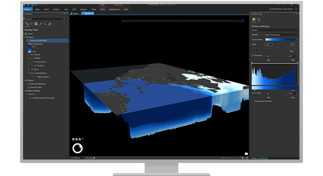
Use the state-of-the-art tools in ArcGIS Pro, such as multi-attribute symbology, flexible labeling, and annotation options, to create the world's most stunning maps.
Use wizards and validation tools to share your maps in print, as interactive web maps in ArcGIS Online, and as ArcGIS apps and custom applications.
Enhance your maps with ArcGIS Living Atlas of the World, the foremost collection of geographic information from around the globe. Access basemaps and integrate data from authoritative sources.
Investigate your data by interactively creating graphics and editing analysis parameters on the fly. Manipulate analysis parameters and receive real-time visual feedback.
Process, manage, and analyse a range of powerful data types on a single map using ArcGIS Pro.
Activate and administer users in your ArcGIS Online or ArcGIS Enterprise organisation. Ensure everyone has secure access to the capabilities, data, and apps they need to do their work.
Build beautiful maps in 2D and 3D, and perform robust geospatial analysis.
Create maps, perform spatial analyses, and share results with stakeholders in a variety of ready-to-use apps.
Explore Creator
Securely view your organisation's maps and apps to monitor performance, and use location data to make better decisions.
Explore Viewer
Connect the field to the office using apps for real-time data collection, tasking, and operations.
Explore Field Worker
Edit and add spatial data to improve accuracy, and provide current authoritative information across the organisation.
Explore Editor
Quickly explore data; analyse multtives using ArcGIS StoryMaps. Embed content from your organisation, or create express maps.
Explore Insights Analyst
Make digital narratives using ArcGIS StoryMaps. Embed content from your organisation, or create express maps.
Explore Storyteller
Other Ways to Contact Us
Office Locations