Why we love it
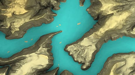
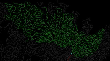
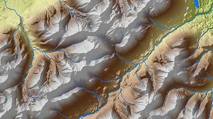
You don't have to look at the legend to understand what this map conveys. It depicts 28,000 miles of previously unmapped waterways and critical habitat in South Central Alaska’s Matanuska-Susitna (Mat-Su) Basin. Using gray scale and opacity to mask everything outside the study area, the map provides a clear delineation of the watershed boundaries. In contrast, vibrant colours within the basin successfully draw the reader in and keep the focus on the intended theme of the map.
Why it works
The Matanuska-Susitna Basin has a complex geography and dense hydrologic network of streams, rivers, and lakes. This map works by employing important techniques to present a striking view of the entire area. The map author uses colour masterfully to highlight and accentuate the most important elements. Additionally, only the most critical labels are provided for reference. As an observer, we get a clear and unimpeded representation of the Mat-Su Basin and its conglomerate of hydrologic features.
Important steps
Update dataset and choose symbology
Clip glaciers out of DEM
Show ocean depths, coastlines and contours
Use greyscale background to emphasis areas
Requirements
Data
Analysis
Time
Tips and tricks
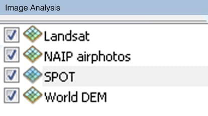
Use image analysis window for raster datasets
Clip and mask your DEM to tell them apart
Add character to transitions with symbology
Resources
Map Author
Jim DePasquale
Jim is a spatial analyst with the Alaska Chapter of The Nature Conservancy.