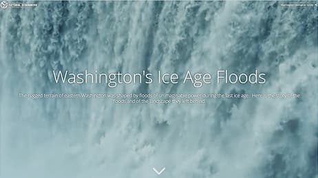
Why we love it
We love how these maps allow you to see through the thin layer of trees and vegetation that hides eons of natural processes at work. Many of Earth's processes occur on a time scale much longer than a human lifetime, making it difficult to gain a comprehensive understanding of them. What if we could lift the veil of time to see evidence accumulated over thousands of years? These maps reveal both events of short duration with multiple repeat appearances in the same area and single, long-term events working at a glacial pace. You can see something different each time you view them.
Why it works
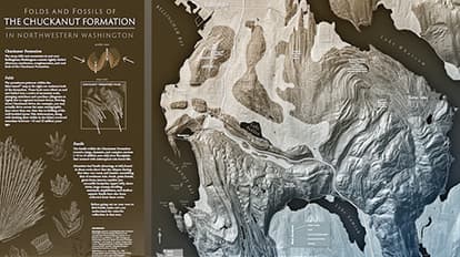
These maps work because they depict the bare earth using colour, contrast and layouts that uncover the evidence revealed by lidar, no matter the natural process. The swipe tool lets you easily pull a blanket of vegetation and trees back from the bare earth like a geologist reading the land to see the formations hidden underneath. Each map in the story has purpose, made clear by subtle colour choices and hillshading. This story map won First Place in Esri's 2018 Storytelling with Maps Contest.
Important steps
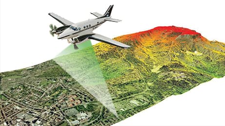
Assemble and resample data
Use lidar-derived data to create this map. Resample it to an appropriate resolution for the map scale.
Create multiple models and layers
Make multiple digital elevation models and hillshade layers with different visual parameters. Colourise and overlay layers for the desired terrain visualisation.
Produce clear map labels
Use transparency and toned-down colours to make your labels clear without distracting from the map.
Use graphics software
Enhance colours and smoothly blend raster layers with graphics software.
Requirements
Data and software
Data sources include Washington State Department of Natural Resources, University of Washington, Washington Geological Survey and Washington Division of Geology and Earth Resources. ArcGIS Desktop and Adobe Creative Cloud served as the software components.
Analysis
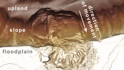
Create and blend multiple lidar hillshades with varying parameters to create visually pleasing terrain. Blend multiple digital elevation models and relative elevation model layers with different colour ranges to emphasise low-lying areas and landforms.
Time
Each map took several days to create. Most of the time was spent creating the lidar images and basemap, and the rest was spent on labeling and descriptions. The story map itself took about five days to make and underwent a few reviews before arriving at the final version.
Tips and tricks
Build a print map
For a subject as fascinating and rich in data as geology, a print map can carry the detail needed at a specific map size and scale. Online maps are beautiful and convenient, but there is something special about having a printed map in your hands or up on your wall.
Search the literature for ideas
Agencies like Washington Geological Survey share their knowledge in peer-reviewed papers. Here is an example: Protocol for landslide inventory mapping from lidar data in Washington State, Slaughter, S. L.; Burns, W. J.; Mickelson, K. A.; Jacobacci, K. E.; Biel, Alyssa; Contreras, T. A., 2017, Bulletin 82 (PDF + Data)
Story Maps tips and tricks
Learn how to use Esri's storytelling apps to build your own place-based multimedia experiences. This session will summarise the most popular storytelling apps and show you how to build, edit,and publish informative and engaging story maps.
Resources
Map Author
Washington Geological Survey
Our mission is to collect, develop, use, distribute, and preserve geologic information. We work to promote the safety, health, and welfare for the citizens of Washington; protect the environment; and support the economy.